Don't Leave Port Without One!
Easiest Navigation Chart For Your Boat You Will Ever Use!
Welcome to Coastal Charts & Maps
Voted #1 – Most Popular Navigation Chart – Since 1996
We were founded on the idea that boaters, from cruisers to kayakers, require charts that aid the boater. Generally, most paper charts are useless in a wet environment. Furthermore, we are talking about boating.
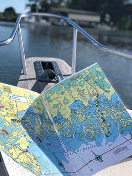
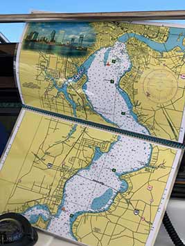
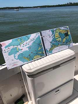
Additionally, chart size of 11 x 17 double sided with great color was selected. Moreover, this chart size is easy to handle in all conditions eliminating the storage problems associated with rolled up large charts and clumsy chart kits. Conversely, we have been on the right track since 1996 and we know this because larger companies try and duplicate what we do.
The principals in Coastal Charts & Maps bring over 35 years of Boating, Cruising and Boat Building into this business and with the ability to provide customized charts, Coastal Charts & Maps established itself as the leader in this unique field.

“I have worked with Larry and Linda for 4 years now, and could not be more grateful for the quality product they produce. Nevertheless, Coastal Charts has provided us with charts for every boat we have in fleet at our 3 Freedom Boat Club locations for our 300+ members to use – AND THEY USE THEM! Significantly it is not always easy to figure out the latest in GPS products on the water, and there are occasions that they do not work. As a USCG Licensed Captain, I feel to have actual charts on board to use and reference physical charts is one of the smartest and safest items to have on your vessel in addition to the required safety gear. Order your charts for your local waters today!”
Drew Goss, Owner
Freedom Boat Club of West Michigan
Testimonials

The Stanleys
18. December, 2024.
Larry – The Charts are great, will send off a check when I find a post office. Now if you could just settle the wind down so we can get to the Keys.
Happy cruising,
Capt. Randi Olsen - Jacksonville Marine Services of the First Coast, Inc.dba TowBOAT/U.S. 904-728-3709
18. December, 2024.
Larry,
I just want to let you know how much my Tow Boat US captains in Jacksonville appreciate your waterproof charts. We have used your waterproof charts on each of our tow boats since early 2005. These charts are easy to use and have helped on many occasions to coordinate the location of a disabled vessel when the owners do not have a clear picture of where they are located.
My company will continue to use these charts on all of our tow boats as they are easy to maintain and use in heavy weather conditions and at night.
Chuck Morton - U.S. Coast Guard Auxiliary Staff Officer Membership Training Div 15, 7th Coast Guard District
18. December, 2024.
Larry,
Great talking with you again.
I want to let you know how much the Coast Guard Auxiliary appreciates your assistance in providing up to date charts for our classes. Our students really appreciate your charts and the ability to plot on them with a “Sharpie” while they are out at sea, and then wipe them clean for the next voyage.
It is a real safety factor to get boaters in the habit of actively plotting their course run as the Navy does. This way if the GPS decides to quit, they can still know where the were within a 30 minute time span and plot a course to save harbor utilizing their compass, as we used to do before the electronic era.
John Fields
18. December, 2024.
Dear Larry,
While on a recent fishing excursion off the southern coast of Florida, I bought one of your Coastal Charts. It has been one of the most useful navigational aides that I have ever purchased. The heavy wire spiraled bindings and the laminated pages are sturdy enough to support daily use without wear and tear. I found the system to be accurate and user-friendly. The system easily adapts to helm or tower and makes a great visual supplement to existing electronics.
As a testimonial, your system proved to be a “life saver” for this non-resident skipper, as I attempted my first passage of the shallow Sebastian inlet in a 36 Sport Fisher. The special cautions inlay section of your system was extremely helpful. Thanks for you thoroughness!
Keep up the good work!!
Sincerely,
Bob Burke
18. December, 2024.
Dear Larry,
I just wanted to write and tell you how much I like your waterproof charts. They are the perfect size for keeping next to me in the cockpit while I cruise Biscayne Bay and the Keys. They make it easy to keep track of my position with a marker, even in the rain or heavy chop and avoid the shoals and other hazards of this cruising area.
Congratulations on a great product.
Sincerely
Don Sharpe - O’Neil’s Marina, 6701 34th St. South St. Petersburg, Florida 33711 727-867-2585
18. December, 2024.
To Coastal Charts & Maps,
My most recent customer who purchased a 26 foot Montery cruiser enjoyed the Chart Kit of their home area that I presented to him. Both he and his wife were very pleased that the kit had both their names, as well as the name of the boat, and the cover itself even included a picture of their new cruiser!
As you know I was at first reluctant to invest in something that was geared to one customer because of the cost, but now after doing a few kits, I see that the investment pays off through the customers appreciation. It is hard to find new ways to keep both my name and the name of the dealer in front of potential customers, but you have provided a unique and useful product. In fact, every time I sell a boat at O’Neill’s I give out a local kit of my customer’s home area for use with their boat.
I have found both the graphics and the photography on the kits to be superb, as well as their usefulness and durability, and they make a much more useful gift than a keychain.
Keep up the good work!!
Natale - Freedom Boat Club Seattle
18. December, 2024.
Linda,
Thank you so much for working with us on these charts! We love how they turned out. You guys always do amazing work. All of us here at Freedom Boat Club Seattle sure do appreciate all that you do! Thanks again.
Harry Cunningham
18. December, 2024.
Thank you so very much! I will enjoy the use of the chart & remember your efforts each time I sail Cedar Key.
SG
18. December, 2024.
Thanks for a great product!
Karl M.
18. December, 2024.
Dear Linda and Larry,
Thank you again for all of your hard work with this project. As stated before it was one of the many projects that I have been given by Nick and only work with perfections and excellence.
I’ll be certainly be looking you all up when I visit Florida. Thanks again.